Elevate your projects with precision
CADMAP Limited, founded in 2011 by Michael Brett, is a leading surveying and geomatics company in the UK. We provide specialist services including PAS 128 compliant utility mapping, topographical land surveys, measured building surveys, CCTV drainage surveys, laser scanning and BIM modelling, supporting architects, engineers, developers and infrastructure organisations.
We are widely recognised for our expertise in utility surveying and underground mapping, utilising PAS 128 standards and ground penetrating radar to reduce construction risks and prevent underground service strikes. Our CCTV drainage division delivers detailed reports incorporating GPS-referenced asset data, invert levels, flow direction analysis and condition assessments. We operate across London, the South East and the wider United Kingdom with a strong emphasis on accuracy and reliability.
- The whole UK - London, Surrey, Sussex, South East
- Year established: 2011
- Employees: 25
- Licensed
- Insured
- Topographical Surveys
- GPR Surveys
- Measured Building Surveys
- BIM Scanning
- Rebar Scanning
- Concrete Scanning for depth and Rebar
- 3D Scanning
- Revit Models
- Drainage Surveys
- CCTV Drainage Surveys and Jetting
- Full Member the TSA - The Survey Association
- CICES
- Bank transfers
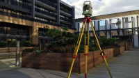 Our land topographical surveys are designed to supply reliable site information for planning, design, and development purposes. We work with architects, planners, developers, and private clients to map land levels and all relevant ground features accurately. Using Leica surveying equipment, our experienced surveyors ensure dependable results for every project. All members of our team are appropriately certified for construction site access and school surveying work.
 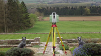 Our measured building surveys are undertaken using 3D laser scanning and Leica total stations to ensure high accuracy. We produce coordinated drawings covering floor plans, elevations, sections, and topographical information. The service supports architects and developers in preparing planning submissions for various property extensions. We supply fully detailed CAD outputs in DWG, DXF, and PDF formats. Every survey is completed to meet recognised RICS standards.
 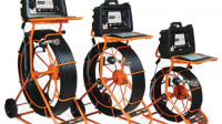 We attend sites using fully equipped LWB printer vans fitted with water jetting systems for drainage clearance. CCTV surveys are carried out on site to inspect underground pipe networks and identify issues. Manhole access points are managed safely to ensure public safety during operations. Survey data is recorded to support accurate reporting of drainage conditions and structure.
 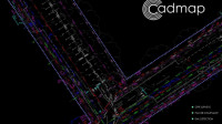 Cadmap Limited provides PAS128 specification GPRS surveys to clients from homeowners to blue chip. A GPR survey is a non-invasive approach for detecting and mapping underground features. Radar pulses penetrate ground and are reflected by differing electrical properties conditions. Data is processed into images or 3D models for construction, utilities, archaeology and drainage purposes outputs.
  At Cadmap Ltd, we specialise in undertaking boundary surveys for private and commercial clients. These surveys require skilled professionals and accurate instruments, as tape measures and Disto tools are insufficient for precise boundary definition. Our services support land disputes, Land Registry requirements, and accurate area measurement. We provide comprehensive plans, demarcation details, and supporting documentation.
 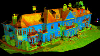 We provide 3D laser scanning and BIM services for a variety of surveying requirements. Leica ScanStation P20 technology enables high-speed capture of dense point cloud data. It is particularly suited to short access periods or high-density capture needs. Our expertise covers building elevations, internal floor plans and specialist surveying projects.